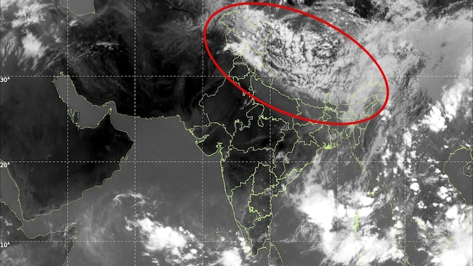
Thermal infrared imagery captured by India’s INSAT-3DS weather satellite has revealed a massive pre-monsoon cloud formation stretching between 2,000 and 2,500 kilometers from west to east. Extending from Pakistan across Punjab, Haryana, Delhi, Uttar Pradesh, and parts of central India, the dense cloud band is moving eastward to merge with atmospheric clusters over the Bay of Bengal.
Meteorologists state the expansive system is driven by an active western disturbance over the western Himalayas interacting with strong moisture incursions from both the Arabian Sea and the Bay of Bengal. The satellite data highlights deep convective activity, indicated by highly reflective, cold cloud tops capable of triggering severe thunderstorms, hailstorms, lightning, and intense rain.
This major atmospheric development arrives after weeks of extreme heatwave conditions across north-central India, where temperatures recently peaked at 48.2 degrees Celsius in Rajasthan’s Sri Ganganagar. While the southwest monsoon continues its steady progress across southern maritime regions, this sudden pre-monsoon transition indicates an accelerated arrival of northern moisture transport. Forecasters anticipate that the ensuing atmospheric instability will soon trigger widespread rain and dust storms, providing widespread relief from the seasonal heat.